
Chapel of the Holy Cross & Sedona's Iconic Landmarks Guide
Sedona's must-see landmarks are the Chapel of the Holy Cross (780 Chapel Rd, free, open 9am–5pm daily), Cathedral Rock, Bell Rock, Courthouse Butte, Coffee Pot Rock, and Snoopy Rock. All are visible from public roads with no fee — the Chapel is the only landmark that's a building. Plan a half-day driving loop to see all six.
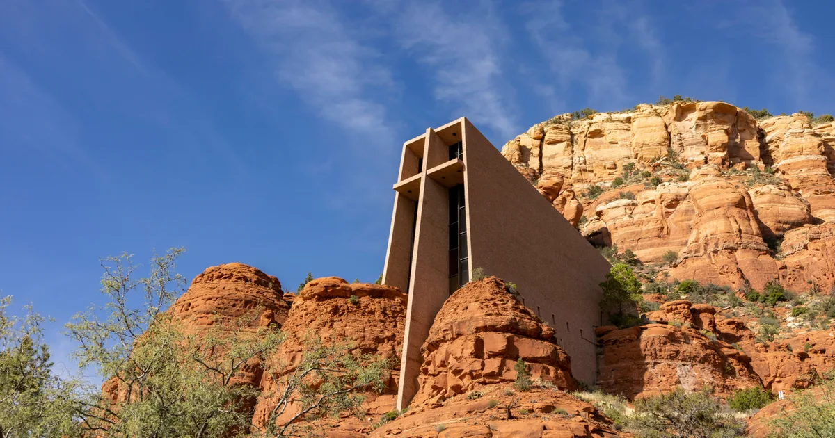
Photo by James A. Molnar on Unsplash
Chapel of the Holy Cross & Sedona's Iconic Landmarks
Quick Answer: Sedona's must-see landmarks are the Chapel of the Holy Cross (780 Chapel Rd, free, open 9am–5pm daily), Cathedral Rock, Bell Rock, Courthouse Butte, Coffee Pot Rock, and Snoopy Rock. All are visible from public roads with no fee — the Chapel is the only landmark that's a building. Plan a half-day driving loop to see all six.
Sedona's red rock formations are the reason you're coming. This guide covers the iconic landmarks — where to see them, park, photograph them, and hike to their base.
Chapel of the Holy Cross
Coordinates: 34.8322°N, 111.7660°W Address: 780 Chapel Road, Sedona, AZ 86336 Hours: 9am–5pm daily Cost: Free (donations welcomed) Google Maps: Chapel of the Holy Cross
Built in 1956 by sculptor Marguerite Brunswig Staude, the Chapel is dramatically wedged into a 200-foot red rock spur between two pinnacles. It's Sedona's most photographed man-made landmark and one of the top spiritual sites in the U.S.
What to know:
- Small, quiet interior — no formal services, but candles for prayer intentions
- Panoramic terrace views of the Red Rocks and the "Twin Buttes"
- Parking lot is small — arrive before 10am or after 3pm to skip the crowds
- Overflow parking on Chapel Road; short walk uphill to the entrance
- Gift shop below the chapel with religious items and Sedona souvenirs
- No restrooms at the Chapel itself
Photography tip: Best light is late afternoon when the cross catches golden hour and the rocks behind glow orange-red.
Fun fact: Staude was inspired to build the Chapel after seeing the Empire State Building in 1932 and envisioning a cross-shaped building for the desert.
Cathedral Rock
Coordinates: 34.8252°N, 111.7884°W Trailhead: Cathedral Rock Trailhead, Back O' Beyond Road (Red Rock Pass required) Google Maps: Cathedral Rock Trailhead
The most photographed natural feature in Sedona — Cathedral Rock's four spires rise from a mesa and are visible for miles. It's also a vortex site (see our Vortex Guide) and one of Sedona's classic hikes.
Best viewing spots:
- Red Rock Crossing at Crescent Moon Recreation Area — the classic postcard shot with Oak Creek in the foreground
- Cathedral Rock Trail (1.2 miles round-trip, strenuous scramble) — reach the saddle between spires
- Sedona Airport Overlook — silhouette view at sunset
Cathedral Rock is best photographed at sunset from Red Rock Crossing, with reflections in Oak Creek. Bring water shoes if you plan to wade across.
Bell Rock
Coordinates: 34.8021°N, 111.7644°W Trailhead: Bell Rock Vista Trailhead (Red Rock Pass required) Google Maps: Bell Rock
A near-perfect bell-shaped butte in the Village of Oak Creek — Bell Rock is easy to spot from Highway 179 and is another vortex site. It's the friendliest of the major formations for casual visitors.
Ways to experience Bell Rock:
- Bell Rock Pathway — flat, paved, wheelchair-accessible loop around the base
- Bell Rock Climb — scramble up the lower shoulders (no permit needed)
- Bell Rock Vista parking lot — best photo spot without hiking
You can drive to Bell Rock Vista and get a full frontal photo in 5 minutes.
Courthouse Butte
Coordinates: 34.8000°N, 111.7602°W Google Maps: Courthouse Butte Sedona
Right next to Bell Rock, Courthouse Butte is the larger, blocky formation. Together they form the iconic silhouette you see on postcards from the Village of Oak Creek.
Courthouse Butte Loop Trail: 4.1-mile loop around the base, moderate difficulty, best hiked clockwise for the shade timing.
Coffee Pot Rock
Coordinates: 34.8858°N, 111.7897°W Google Maps: Coffee Pot Rock Sedona
One of Sedona's most obviously-named formations — it looks exactly like a percolator. Best viewed from West Sedona along Highway 89A or from the Sugarloaf Loop trailhead.
Best viewing spot: Coffee Pot Restaurant parking lot (2050 W AZ-89A) is named for the view — literally frames the rock from its patio.
Snoopy Rock
Coordinates: 34.8557°N, 111.7521°W Google Maps: Snoopy Rock Sedona
From the right angle, this formation looks exactly like Snoopy lying on his doghouse. It's a favorite of kids and one of the most-Instagrammed landmarks in Sedona.
Best viewing spots:
- Schnebly Hill Road (unpaved after the first mile — take it slow)
- Sedona Public Library parking lot
- Uptown Sedona along 89A
Devil's Bridge
Coordinates: 34.9032°N, 111.8140°W Trailhead: Dry Creek Road or Mescal Trailhead Google Maps: Devil's Bridge Trailhead
The largest natural sandstone arch in the Sedona area. It's an Instagram phenomenon — expect a 1-hour+ line to walk out onto the bridge during peak season.
Distance options:
- From Dry Creek Vista trailhead: 4.2 miles round-trip (paved road access)
- From Mescal trailhead: 4.4 miles round-trip
- From end of Dry Creek Road (4WD only): 1.8 miles round-trip
Best strategy: Start before sunrise. The bridge faces east and gets brutal midday sun, plus the line for the "photo spot" can hit 90+ minutes on busy days.
Airport Mesa
Coordinates: 34.8497°N, 111.7905°W Google Maps: Airport Mesa Overlook
Not a red rock formation itself — but the best panoramic viewpoint in Sedona and another vortex site. From the top you see Cathedral Rock, Bell Rock, Courthouse Butte, and Capitol Butte in one sweep.
Best at sunset. Parking is $3/hour or free with a Red Rock Pass.
Capitol Butte (Thunder Mountain)
Coordinates: 34.8905°N, 111.8047°W Google Maps: Capitol Butte Sedona
Also called Thunder Mountain — the massive rounded butte that dominates West Sedona's northern skyline. Best photographed from Airport Mesa or Andante Drive.
Half-Day Landmark Driving Loop
If you only have 4–5 hours, here's the perfect loop to see everything without hiking:
- Bell Rock Vista (Village of Oak Creek) — 15 min
- Chapel of the Holy Cross — 45 min
- Sedona Airport Overlook — 30 min
- Coffee Pot Rock viewpoint (West 89A) — 15 min
- Red Rock Crossing (Cathedral Rock reflection) — 45 min
- Snoopy Rock from Uptown — 15 min
Total drive time: ~90 minutes. Total including stops: ~4 hours.
Chapel of the Holy Cross Etiquette
- Silence inside — this is an active place of worship
- No flash photography inside the chapel
- Modest attire appreciated (no swimwear or bare shoulders)
- Leave donations in the box if you appreciate the visit — the chapel is maintained entirely by donations
- Pets not allowed inside
FAQ
Q: Is the Chapel of the Holy Cross free? Yes, admission is free. The chapel operates on donations, and there's a donation box inside and a gift shop below.
Q: How much time do I need at the Chapel of the Holy Cross? Plan 30–45 minutes total — 10 minutes inside, and time to photograph and admire the views from the terrace.
Q: Can I get married at the Chapel of the Holy Cross? No, the Chapel does not host weddings. It's a place for private prayer and reflection only.
Q: Which Sedona landmark is the most photogenic? Cathedral Rock from Red Rock Crossing is Sedona's most iconic photo. Chapel of the Holy Cross is the best man-made landmark shot.
Q: What's the difference between Bell Rock and Courthouse Butte? They're right next to each other. Bell Rock is the smaller, symmetrical bell-shaped one. Courthouse Butte is the larger, blocky formation directly behind it.
Q: Can you drive to Devil's Bridge? Not to the bridge itself. You can drive Dry Creek Road (paved) to the Vista trailhead, but the actual bridge requires a 4.2-mile round-trip hike.
Related Guides
- Best Photography Spots in Sedona
- Best Hikes in Sedona
- Sedona Vortex Sites Explained
- Best Sunset Spots in Sedona
Planning your Sedona trip? Use SedonaPassport.com to get personalized landmark recommendations, live wait times for Devil's Bridge, and turn-by-turn directions from our Aurora AI concierge.
Topics